


domnique+villars+recalc

frizou83
User
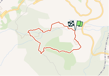

Length
3.7 km

Max alt
1403 m

Uphill gradient
237 m
Km-Effort
6.8 km

Min alt
1164 m

Downhill gradient
240 m
Boucle
Yes
Creation date :
2023-08-14 16:05:55.258
Updated on :
2023-08-14 16:09:56.947
1h33
Difficulty : Medium

FREE GPS app for hiking
 SityTrail
IGN / Geographical institutes
SityTrail Plus
The world is yours!
About
Trail Walking of 3.7 km to be discovered at Provence-Alpes-Côte d'Azur, Hautes-Alpes, Le Noyer. This trail is proposed by frizou83.
Positioning
Country:
France
Region :
Provence-Alpes-Côte d'Azur
Department/Province :
Hautes-Alpes
Municipality :
Le Noyer
Location:
Unknown
Start:(Dec)
Start:(UTM)
262885 ; 4952734 (32T) N.
Comments